
3D Building Scanning and Scan to BIM in Madrid
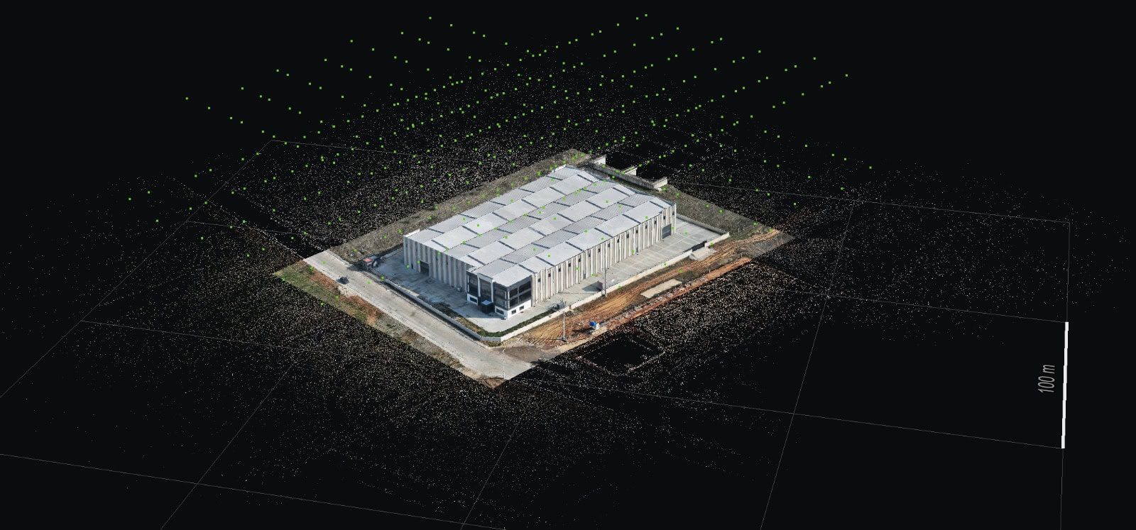
TKM Photo scans interiors, buildings and industrial facilities in 3D across Madrid and Spain, delivering BIM-ready LiDAR point clouds and as-built surveys. We transform physical spaces into precise, measurement-grade digital assets, from interior 3D maps and as-built surveys to photogrammetry outputs and point cloud data sets.
Our services are designed for architects, engineers, facility managers, construction firms, and property developers who need accurate spatial data for renovation planning, compliance reporting, progress monitoring, or facility management.
Based in Chamberí, Madrid. Available across Spain and Europe.
3D Scanning Services in Madrid for Architecture & Industry
Building & Heritage Site Scanning Madrid
We capture full interior environments using high-resolution 3D scanning technology, producing accurate digital replicas of commercial buildings, industrial facilities, warehouses, and architectural spaces. The resulting 3D models can be used for renovation planning, space analysis, investor presentations, and remote facility inspections.
Deliverables: Interactive 3D walkthrough, floor plans, measurement data, dollhouse view, point cloud export.
Typical projects: Warehouses, office buildings, retail spaces, hotel interiors, factories, logistics facilities.
Coverage: Travel logistics are scaled to project scope.
LiDAR Point Cloud Capture
LiDAR scanning delivers high-precision spatial data for complex environments where precision is critical. We produce high-density point clouds that serve as the foundation for BIM modelling, structural analysis, and engineering documentation.
Deliverables: Registered point cloud (.e57, .las, .rcp), coloured point cloud, section cuts, measurement reports.
Applications: Structural surveys, renovation planning, heritage documentation, MEP coordination, industrial facility mapping.
Accuracy: Defined per project. The scanner and workflow are selected for the tolerance your deliverable needs, and the achievable accuracy is stated in the quote.
BIM-Ready Point Cloud Delivery (Scan-to-BIM)
We deliver point cloud data sets formatted and prepared for direct import into BIM workflows. Our scan data is compatible with Autodesk Revit, ArchiCAD, and other industry-standard BIM platforms, enabling architects and engineers to work with accurate, real-world spatial data.
Deliverables: Registered point clouds in E57 and RCP/RCS, BIM model in Revit (.rvt) and IFC, and floor plans, sections and elevations in DWG and PDF.
LOD levels: BIM models from LOD 200 to LOD 300, set according to what the project needs.
Industrial Equipment 3D Documentation Madrid
Accurate as-built documentation captures the current state of a building or facility, essential for renovation projects, regulatory compliance, insurance records, and property transactions. We combine 3D scanning with professional photography to produce comprehensive as-built packages.
Deliverables: Verified floor plans, elevation drawings, point cloud data, photographic documentation, measurement reports.
Sectors: Real estate, construction, industrial facilities, heritage buildings, property management.
Construction Progress Monitoring
Regular 3D scans at defined intervals create a time-series record of construction progress. This data supports project management, investor reporting, dispute resolution, and quality verification, providing objective, measurement-grade evidence of site conditions at each stage.
Deliverables: Periodic 3D scan comparisons, progress overlay reports, deviation analysis, photo + scan documentation packages.
Frequency: Weekly, biweekly, or monthly scan schedules available.
Drone-Integrated Aerial Scanning
For large-scale sites, we combine ground-level 3D scanning with registered drone photogrammetry to capture complete facility documentation, from roof conditions to site boundaries. TKM Photo is AESA-registered and operating under the EASA framework for commercial drone operations across the EU, with project specific flight permits and airspace coordination handled where required.
Deliverables: Orthomosaic maps, aerial photogrammetry, volumetric calculations, combined aerial + interior 3D models.
Registration and certificates: AESA operator registration with A1, A2 and A3 remote pilot certificates under the EASA framework. Every assignment is covered by civil liability insurance, and the certificate is sent to your project manager or safety officer before the shoot.
See our full Aerial Photography & Drone services
Thermal Imaging & Building Analysis
Thermal imaging reveals hidden issues that standard photography cannot capture, insulation defects, moisture intrusion, HVAC inefficiencies, and electrical hotspots. We offer thermal imaging as a standalone inspection service or as a complement to our 3D scanning packages, providing a complete diagnostic picture of building performance.
Deliverables: Calibrated thermal images, temperature differential reports, overlay visualisations (thermal + standard photo), defect location mapping.
Applications: Energy audits, building envelope inspections, industrial equipment monitoring, pre-purchase property assessments, insurance documentation.
Standards: Reporting aligned with ISO 6781 (thermal performance of buildings) guidelines.
What Can 3D Scanning Be Used For in Madrid?
Our clients include architects planning renovations who need accurate existing-condition data, construction managers tracking build progress across multiple sites, facility managers documenting industrial plants for maintenance planning, property developers preparing investor-grade documentation, and engineering firms requiring point cloud data for structural analysis. We work regularly with international companies operating in Madrid who need documentation delivered in English with professional communication throughout the project.
Our 3D Scanning Equipment & LiDAR Technology Madrid
We choose the equipment for each project according to the required accuracy, the scale of the site and the budget.
3D Scanning: Share S20 SLAM laser scanner for mobile capture of interiors and facades, Matterport Pro for interior mapping and virtual tours, 3DMakerPro Eagle 3D LiDAR Scanner for high-density point cloud capture. When a brief demands tighter tolerances, survey grade instruments are brought in for that assignment.
Aerial: DJI Enterprise Matrice 350 RTK for large-scale industrial photogrammetry, DJI Mavic 3 Enterprise for agile site documentation.
Georeferencing: CHC i89 GNSS receiver for ground control points that place the point cloud and the model in real-world coordinates (ETRS89 / UTM 30N).
Software: Data processed using Autodesk Revit, AutoCAD, and industry-standard BIM/CAD platforms. Deliverables are compatible with all major BIM, CAD, and GIS workflows.
All scan data is processed and quality-checked in-house before delivery.
How Our Madrid 3D Scanning & LiDAR Process Works
1. Project Brief & Site Assessment
We discuss your documentation requirements, review site conditions, and determine the appropriate scanning approach. For industrial environments, we confirm PPE and safety requirements in advance. TKM Photo holds current PRL (Prevención de Riesgos Laborales) certification, and every assignment is covered by civil liability insurance.
2. On-Site Scanning & Capture
Our team arrives with all necessary equipment and safety gear. Scanning is conducted efficiently to minimise disruption to your operations. Most interior spaces under 1,000m² are completed within a single day.
3. Processing & Delivery
Raw scan data is registered, cleaned, and processed into your specified deliverable format. Standard turnaround is 5 to 10 business days, with the exact delivery date agreed per project. Priority Delivery is available as a paid add on. Rush processing available upon request.
Why International Companies Choose Our Madrid 3D Scanning
Industrial Access & Safety Compliance
PRL certified with full PPE kit, and every assignment is covered by civil liability insurance. We operate in factories, construction sites, warehouses, and restricted-access facilities without creating compliance issues for your HSE team.
Photography + Scanning Integration
We combine 3D scanning with professional industrial and architectural photography in a single site visit, reducing your coordination overhead and project timeline.
Bilingual Communication, English & Spanish
Clear, professional reporting in English for international teams, investors, and stakeholders, with Spanish coordination available for local briefings and liaison with authorities. No translation delays, no misunderstandings.
Registered Drone Capability
AESA registered drone operations for complete site documentation, ground-level scanning plus aerial photogrammetry in one provider.
Frequently Asked Questions
3D scanning uses laser or structured-light technology to capture precise measurements of physical spaces, creating a digital point cloud, a detailed 3D representation of the scanned environment. Architects use this data for renovation planning, engineers use it for structural analysis, and facility managers use it for maintenance documentation and space management.
LiDAR scanning uses laser pulses to measure distances directly, which makes it the right base for engineering-grade documentation. Photogrammetry uses overlapping photographs to reconstruct 3D geometry and is better suited for large outdoor areas and aerial mapping. We use both technologies depending on project requirements, and they can be combined for comprehensive documentation.
We deliver point clouds in industry-standard formats including .e57, .las, .rcp, and .ply. Additional outputs include .obj and .fbx for 3D visualisation, .dwg for CAD workflows, and .pdf for measurement reports.
Accuracy depends on the instrument and workflow selected for the project, together with scan distance, environmental conditions and target surface. We match the equipment to the tolerance your deliverable needs, and the achievable accuracy is stated in the quote before the work begins.
Yes. We deliver the BIM model in Revit (.rvt) and IFC, from LOD 200 to LOD 300, together with the registered point cloud and the drawings in DWG and PDF. The LOD and the scope of the model are set in the quote.
Yes. We bring our own PPE and comply with site-specific HSE protocols. We have experience documenting factories, warehouses, production lines, and construction sites across Madrid and Spain.
Thermal imaging detects temperature variations across building surfaces, revealing insulation gaps, moisture intrusion, air leaks, HVAC inefficiencies, and electrical faults that are invisible to the naked eye.
Most interior spaces under 1,000m² can be scanned in a single day. Larger facilities or multi-building sites may require 2 to 3 days of on-site work.
Yes. We are based in Chamberí, Madrid, and regularly work across the Madrid metropolitan area, including industrial corridors in Toledo, Guadalajara, and surrounding provinces. We also accept projects throughout Spain and Europe, travel logistics are included in our project quotes.
Do you handle drone flight permits and authorisations?
Yes. We manage the entire bureaucratic process; flight permits, airspace authorisations, coordination with local authorities and all regulatory paperwork. You focus on your project; we handle the approvals and deliver complete compliance documentation.
More answers on the FAQ page, or ask us and you get an answer within one business day.
Request a 3D Scanning Quote
Tell us about your project, location, approximate area, and documentation requirements and we will provide a detailed quote within one business day.
ContactFor a worked example, see the Metro rooftop solar and 3D scanning case study, where the point cloud became as built survey documentation for an engineering team.
Working with us
- Crew
- Standard crew is one photographer. A second photographer, a drone pilot or a lighting assistant are added by scope and quoted per line, so you can see what each one costs and decide whether the shoot needs it.
- Booking and rescheduling
- A non refundable booking fee reserves the date and is credited against the final invoice. Rescheduling is free more than 72 hours before the shoot. Weather is never charged: if conditions make the work impossible we move the date at no cost. If we cancel, the booking fee is refunded in full.
- Licensing
- Retail and brand work includes a broad commercial licence in the fee, because those images are made to be published. Industrial and architectural work is quoted with a licence line of its own, since the same photograph can serve an internal report or a global campaign and those are not the same thing. The parameters that set it are the territory, the duration, the media, and whether third parties such as suppliers or architects may use the files.
- Insurance and site access
- Every assignment is covered by civil liability insurance, and the certificate is sent to your project manager or safety officer before the shoot. We work with our own PPE. Site inductions, safety briefings and access paperwork are handled before the shoot day rather than at the gate.
- Delivery and retouching
- Final delivery runs 5 to 10 days after the shoot, in web and print resolutions, unless the service page or the quotation states a different delivery time, which then applies. Standard colour and perspective correction is included. Object removal, compositing and other advanced retouching is quoted separately, per image.
- Confidentiality
- We sign your NDA. Where a project is confidential, nothing from it appears in a portfolio, a case study or a social post, and that holds after the work is delivered and paid.